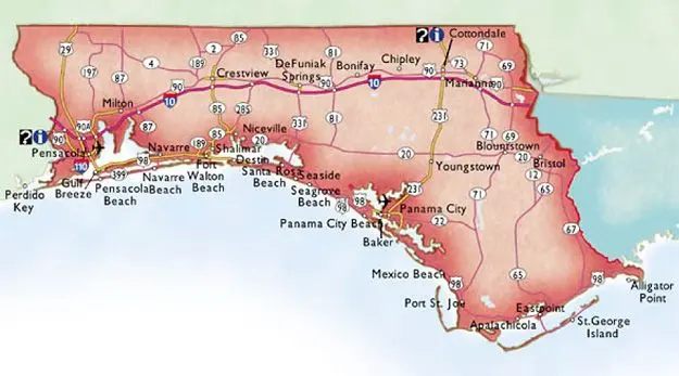
Map of Florida Gulf Coast: Beaches, Cities & Natural Wonders
The map of Florida Gulf Coast reveals a stunning stretch of shoreline along the western edge of the Sunshine State. This picturesque region, known for its pristine beaches, vibrant coastal communities, and diverse ecosystems, offers a wealth of attractions for visitors and residents alike. In this comprehensive guide, we’ll dive deep into the various aspects of the Florida Gulf Coast, using the map as our guide to uncover the region’s hidden gems and popular destinations.
Understanding the Geography of the Florida Gulf Coast
When examining a map of Florida Gulf Coast, you’ll notice that it spans approximately 770 miles from the Panhandle in the northwest to the Ten Thousand Islands in the southwest. This extensive coastline is characterized by:
- White sandy beaches
- Barrier islands
- Coastal wetlands
- Estuaries and bays
The Gulf Coast region is generally considered to include the following areas:
- Northwest Florida (The Panhandle)
- Big Bend
- Central West Florida
- Southwest Florida
Each of these areas has its own unique features and attractions, which we’ll explore in more detail throughout this article.
Key Cities and Towns Along the Florida Gulf Coast
When studying a map of Florida Gulf Coast, you’ll encounter numerous cities and towns that dot the shoreline. Some of the most notable include:
- Pensacola
- Panama City Beach
- Destin
- Apalachicola
- Tampa
- St. Petersburg
- Sarasota
- Fort Myers
- Naples
These coastal communities offer a range of experiences, from bustling urban centers to quaint fishing villages, each with its own distinct charm and character.
Natural Wonders on the Map of Florida Gulf Coast
The Florida Gulf Coast is home to an array of natural wonders that are easily identifiable on a map. Some of the most significant include:
1. Gulf Islands National Seashore
Stretching across Florida and Mississippi, this national park features pristine barrier islands, historic forts, and diverse wildlife.
2. Apalachicola National Forest
As the largest national forest in Florida, it offers numerous recreational opportunities and is home to unique ecosystems.
3. Crystal River National Wildlife Refuge
Known for its population of West Indian manatees, this refuge is a must-visit for nature enthusiasts.
4. Everglades National Park
While not entirely on the Gulf Coast, this iconic national park extends to the southwestern tip of Florida and is a crucial part of the region’s ecosystem.
Popular Beaches Along the Florida Gulf Coast
A map of Florida Gulf Coast wouldn’t be complete without highlighting its world-renowned beaches. Some of the most popular include:
- Clearwater Beach
- Siesta Key Beach
- Naples Beach
- St. Pete Beach
- Pensacola Beach
- Panama City Beach
These beaches are known for their soft, white sand and crystal-clear waters, making them popular destinations for sunbathers, swimmers, and water sports enthusiasts.
Major Bodies of Water on the Map of Florida Gulf Coast
When examining a map of Florida Gulf Coast, you’ll notice several significant bodies of water that shape the region’s geography:
- Gulf of Mexico: The primary body of water along the coast
- Tampa Bay: A large natural harbor and estuary
- Charlotte Harbor: One of the largest natural harbors in Florida
- Apalachicola Bay: Known for its oyster production
- Choctawhatchee Bay: A coastal lagoon in the Panhandle region
These bodies of water play crucial roles in the region’s ecology, economy, and recreational activities.
Islands and Keys on the Florida Gulf Coast Map
The map of Florida Gulf Coast features numerous islands and keys that are worth exploring:
- Santa Rosa Island
- St. George Island
- Cedar Key
- Sanibel Island
- Captiva Island
- Marco Island
Each of these islands offers unique experiences, from secluded beaches to wildlife preserves and historic landmarks.
Major Highways and Transportation Routes
When planning a trip along the Florida Gulf Coast, it’s essential to familiarize yourself with the major transportation routes visible on the map:
- Interstate 10 (I-10): Runs east-west through the Panhandle
- Interstate 75 (I-75): Runs north-south along the central and southern Gulf Coast
- US Highway 98: Follows much of the coastline from the Panhandle to Central Florida
- US Highway 41: Connects Tampa to Miami along the southern Gulf Coast
These highways provide easy access to various destinations along the coast and connect major cities and attractions.
Economic Hubs on the Map of Florida Gulf Coast
The Florida Gulf Coast is home to several important economic centers that contribute significantly to the state’s economy:
- Tampa Bay Area: A major business and cultural center
- Naples-Fort Myers: Known for tourism and retirement communities
- Pensacola: Home to important military installations and aerospace industries
- Panama City: A popular tourist destination with a growing technology sector
These economic hubs offer diverse employment opportunities and contribute to the region’s overall prosperity.
Climate and Weather Patterns Along the Gulf Coast
Understanding the climate and weather patterns is crucial when interpreting a map of Florida Gulf Coast:
- The region generally experiences a subtropical climate
- Summers are hot and humid, with frequent afternoon thunderstorms
- Winters are mild, with occasional cold fronts bringing cooler temperatures
- The hurricane season runs from June to November, with peak activity in August and September
Climate and weather patterns can vary slightly depending on the specific location along the coast, with the northern regions experiencing somewhat cooler winters compared to the southern areas.
Exploring the Underwater World: Diving and Snorkeling Spots
The map of Florida Gulf Coast reveals numerous diving and snorkeling opportunities:
- John Pennekamp Coral Reef State Park
- Destin’s artificial reefs
- Venice Beach (known as the “Shark Tooth Capital of the World”)
- The Florida Keys National Marine Sanctuary
These underwater attractions offer glimpses into diverse marine ecosystems and provide unforgettable experiences for water enthusiasts.
Cultural and Historical Sites on the Gulf Coast Map
The Florida Gulf Coast is rich in history and culture, with many significant sites marked on maps:
- St. Augustine: The oldest continuously inhabited European-established settlement in the United States
- Pensacola: Home to historic forts and the National Naval Aviation Museum
- Tarpon Springs: Known for its Greek heritage and sponge diving industry
- Ybor City (Tampa): A historic neighborhood famous for its Cuban and Italian influences
These sites offer visitors a chance to delve into the region’s diverse cultural heritage and historical significance.
State Parks and Preserves Along the Florida Gulf Coast
A map of Florida Gulf Coast will highlight numerous state parks and preserves that protect the region’s natural beauty:
- Honeymoon Island State Park
- Caladesi Island State Park
- Lovers Key State Park
- Fakahatchee Strand Preserve State Park
- St. Andrews State Park
These protected areas offer opportunities for hiking, wildlife viewing, and enjoying unspoiled natural environments.
Fishing Hotspots on the Gulf Coast Map
Fishing enthusiasts will find plenty of opportunities along the Florida Gulf Coast:
- Destin: Known as the “World’s Luckiest Fishing Village”
- Apalachicola Bay: Famous for its oysters and diverse fish species
- Tampa Bay: Offers both inshore and offshore fishing opportunities
- Charlotte Harbor: A premier destination for tarpon fishing
Whether you prefer deep-sea fishing or casting a line from the shore, the Gulf Coast has something for every angler.
Planning Your Trip Using a Map of Florida Gulf Coast
When planning a trip to the Florida Gulf Coast, a map can be an invaluable tool. Here are some tips for using a map effectively:
- Identify your starting point and destination
- Plan your route using major highways and scenic byways
- Mark points of interest along the way
- Consider the distances between locations and plan accordingly
- Use the map to identify nearby accommodations and amenities
By utilizing a map of Florida Gulf Coast, you can create a well-organized itinerary that allows you to make the most of your visit to this beautiful region.
Conservation Efforts and Environmental Concerns
As you explore the map of Florida Gulf Coast, it’s important to be aware of the ongoing conservation efforts and environmental concerns in the region:
- Beach erosion and restoration projects
- Protection of endangered species, such as sea turtles and manatees
- Water quality issues, including red tide and algal blooms
- Preservation of coastal wetlands and mangrove forests
Understanding these issues can help visitors appreciate the delicate balance of the Gulf Coast ecosystem and encourage responsible tourism.
Conclusion
A map of the Florida Gulf Coast is more than just a navigational aid; it’s a key to discovering the region’s diverse attractions, natural wonders, and cultural richness. Whether you’re a visitor or a resident, using a map helps you uncover hidden gems, navigate efficiently, and fully appreciate the interconnected ecosystems and communities of this unique coastal area. With a map in hand, you’re ready to embark on an unforgettable adventure along the Florida Gulf Coast, where the possibilities are endless.